
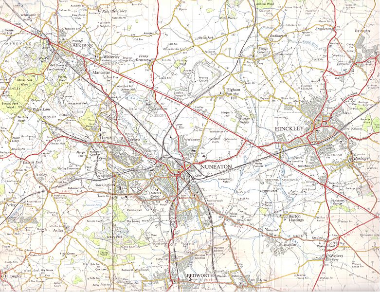
Image: Nueaton Hinkley 1961 OS

Size of this preview: 781 × 600 pixels. Other resolutions: 313 × 240 pixels | 6,482 × 4,978 pixels.
Original image (6,482 × 4,978 pixels, file size: 9.98 MB, MIME type: image/jpeg)
Description: A 1961 1 inch = 1 mile series map. Copy right was 50 years and ran out in 2011. It covers Hinkley, Nuneaton, part of Bedworth, Atherstone, Arsley, Burton Hastings, Harts Hill and Wovley. Harts Hill quarry is attached to a railway and in full swing. The coal mines near Griff Lodge Farm and Ansely Hall are in early decline. The mines are now shut and the quarry is (as far as I know) a rubbish-tip. Note the even by then removed railway by Higham Grange and Higham on the Hill.
Title: Nueaton Hinkley 1961 OS
Credit: A 1961 1 inch = 1 mile series map. Copy right was 50 years and ran out in 2011.
Author: Ordinance servery maps, UK
Usage Terms: Public domain
License: Public domain
Attribution Required?: No
Image usage

All content from Kiddle encyclopedia articles (including the article images and facts) can be freely used under Attribution-ShareAlike license, unless stated otherwise.