
Image: Oceania UN Geoscheme Regions

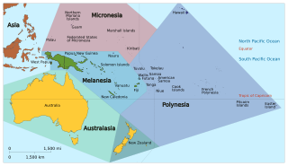
Description: Map of Oceania based on the United Nations geoscheme M49 coding classification devised by the United Nations Statistics Division. Exceptions: New Zealand shown in both Australia (as per UN geozones) as well as Polynesia and so needs a qualifier description on any Wiki article; Hawaii and Easter Island shown which belong to USA and Chile in the 'Americas' geozone. SVG format.
Title: Oceania UN Geoscheme Regions
Credit: Own work, derivative of Oceania_ISO_3166-1.svg
Author: source: Oceania_ISO_3166-1.svg: User:Tintazul derivative work: Cruickshanks
Usage Terms: Creative Commons Attribution-Share Alike 3.0
License: CC BY-SA 3.0
License Link: https://creativecommons.org/licenses/by-sa/3.0
Attribution Required?: Yes
Image usage
The following 2 pages link to this image:
