
Image: Old River Lake Battlefield Arkansas

Size of this preview: 785 × 600 pixels. Other resolutions: 314 × 240 pixels | 1,820 × 1,390 pixels.
Original image (1,820 × 1,390 pixels, file size: 830 KB, MIME type: image/jpeg)
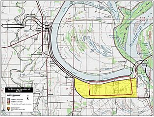
Description: Map of battlefield core and study areas. The 1993 Study Area was modified to reflect the position of the Mississippi River circa 1864, the correct location of Sunnyside Landing (the Federal point of debarkation and encampment), troop movements, and avenues of approach and withdrawal. The Core Area was narrowed slightly to better represent the positions of the opposing battle lines.
Title: Old River Lake Battlefield Arkansas
Credit: National Park Service
Author: American Battlefield Protection Program
Usage Terms: Public domain
License: Public domain
Attribution Required?: No
Image usage
The following page links to this image:

All content from Kiddle encyclopedia articles (including the article images and facts) can be freely used under Attribution-ShareAlike license, unless stated otherwise.