
Image: Operation Tractable

Size of this PNG preview of this SVG file: 490 × 599 pixels. Other resolution: 196 × 240 pixels.
Original image (SVG file, nominally 548 × 670 pixels, file size: 493 KB)
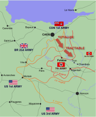
Description: Map of Allied and German positions around Falaise, Normandy from 8-17 August 1944, illustrating the Canadian offensives of Operation Totalize and Operation Tractable.
Title: Operation Tractable
Credit: Own work
Author: EyeSerene (talk)
Usage Terms: Creative Commons Attribution-Share Alike 4.0
License: CC BY-SA 4.0
License Link: https://creativecommons.org/licenses/by-sa/4.0
Attribution Required?: Yes
Image usage
The following 3 pages link to this image:

All content from Kiddle encyclopedia articles (including the article images and facts) can be freely used under Attribution-ShareAlike license, unless stated otherwise.