
Image: Ordnance Survey Tide Gauge House, Dunbar Harbour, East Lothian

Size of this preview: 800 × 600 pixels. Other resolutions: 320 × 240 pixels | 4,606 × 3,454 pixels.
Original image (4,606 × 3,454 pixels, file size: 5.79 MB, MIME type: image/jpeg)
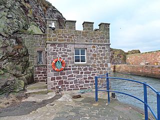
Description: Ordnance Survey Tide Gauge House, Dunbar Harbour, East Lothian - now the harbour master's house. OS set up tide gauges in Felixstowe (1913), Newlyn (1915) and Dunbar (1913). Newlyn was chosen as the single reference.
Title: Ordnance Survey Tide Gauge House, Dunbar Harbour, East Lothian
Credit: Own work
Author: Rosser1954
Usage Terms: Creative Commons Attribution-Share Alike 4.0
License: CC BY-SA 4.0
License Link: https://creativecommons.org/licenses/by-sa/4.0
Attribution Required?: Yes
Image usage
The following page links to this image:

All content from Kiddle encyclopedia articles (including the article images and facts) can be freely used under Attribution-ShareAlike license, unless stated otherwise.