
Image: Oso landslide geomorphology map

Size of this preview: 800 × 527 pixels. Other resolutions: 320 × 211 pixels | 1,139 × 750 pixels.
Original image (1,139 × 750 pixels, file size: 634 KB, MIME type: image/png)
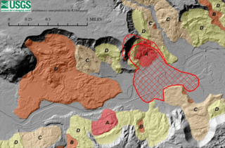
Description: Lidar base map and overlays of Oso Landslide of 2014
Title: Oso landslide geomorphology map
Credit: U.S. Geological Survey Open-File Report 2014–1065 http://pubs.usgs.gov/of/2014/1065/pdf/ofr2014-1065.pdf
Author: Ralph A. Haugerud (USGS)
Permission: Federal governemnt/USGS
Usage Terms: Public domain
License: Public domain
Attribution Required?: No
Image usage
The following page links to this image:

All content from Kiddle encyclopedia articles (including the article images and facts) can be freely used under Attribution-ShareAlike license, unless stated otherwise.