
Image: Ottoman Empire Administrative Divisions

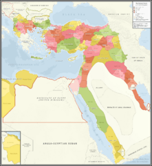
Description: A detailed map showing the Ottoman Empire and it's dependencies, including it's administrative divisions, in 1317 Hijri, 1899 Gregorian
Title: Ottoman Empire Administrative Divisions
Credit: Own work, The Sources that back up the maps are as follows: [1] Pavet de Courteille, Abel (1876). État présent de l'empire ottoman (in French). J. Dumaine. pp. 91–96. (for yemen) [2] http://tarihvemedeniyet.org/2009/10/trablus-garb-vilayeti.html for tripolitania [3] http://tarihvemedeniyet.org/2009/10/bosna-vilayeti.html for bosnia [4] https://www.nsi.bg/nrnm/index.php?i=1&ezik=en for eastern rumelia [5] http://hdl.loc.gov/loc.gmd/g7431f.ct002181 (Rest of ottoman subdivisions, taken from the United States Library of Congress's Geography & Map Division, digital ID g7431f.ct002181)
Author: AbdurRahman AbdulMoneim
Usage Terms: Creative Commons Attribution-Share Alike 4.0
License: CC BY-SA 4.0
License Link: https://creativecommons.org/licenses/by-sa/4.0
Attribution Required?: Yes
Image usage
The following 2 pages link to this image:
