
Image: Overall precipitation from Hurricane Dorian

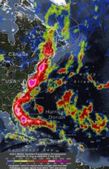
Description: The near-real-time rain estimates come from the NASA’s IMERG algorithm, which combines observations from a fleet of satellites, in near real time, to provide near-global estimates of precipitation every 30 minutes. Supplementary, circles at one-day intervals show the distance that tropical-storm-force (39 mph) winds extended from Hurricane Dorian’s low-pressure center, as estimated by the National Hurricane Center. The Saffir-Simpson hurricane-intensity category is the number following the “H” in the label on the image. “TS” or “PT” indicate times when the storm was either at tropical storm strength or when the storm was categorized as post-tropical. Red circles over North Carolina indicate preliminary reports of tornadoes on Sept. 5.
Title: Overall precipitation from Hurricane Dorian
Credit: https://blogs.nasa.gov/hurricanes/tag/dorian-2019/
Author: NASA's IMERG
Usage Terms: Public domain
License: Public domain
Attribution Required?: No
Image usage
The following page links to this image:
