
Image: PIA03445

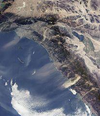
Description: The Santa Ana winds in Southern California sweep down across the deserts and across the Los Angeles Basin pushing dust and smoke from wildfires far out into the Pacific Ocean. This view from the Multi-angle Imaging SpectroRadiometer shows the pattern of airborne dust stirred up by Santa Ana winds on February 9, 2002. The image is from MISR's 70-degree forward-viewing camera, and airborne particulates are especially visible due to the camera's oblique viewing angle. Southeast of the Los Angeles Basin, a swirl of dust, probably blown through the Banning Pass, curves toward the ocean near Dana Point. The largest dust cloud occurs near Ensenada, in Baja California, Mexico. Also visible in this image is a blue-gray smoke plume from a small fire located near the southern flank of Palomar Mountain in Southern California. This image was acquired during Terra orbit 11423, and represents an area of about 410 kilometers x 511 kilometers.
Title: PIA03445
Credit: http://photojournal.jpl.nasa.gov/catalog/PIA03445
Author: NASA/JPL-Caltech
Usage Terms: Public domain
License: Public domain
Attribution Required?: No
Image usage
The following image is a duplicate of this image (more details):
The following page links to this image:
