
Image: PIA18788-VestaAsteroid-GeologicMap-DawnMission-20141117
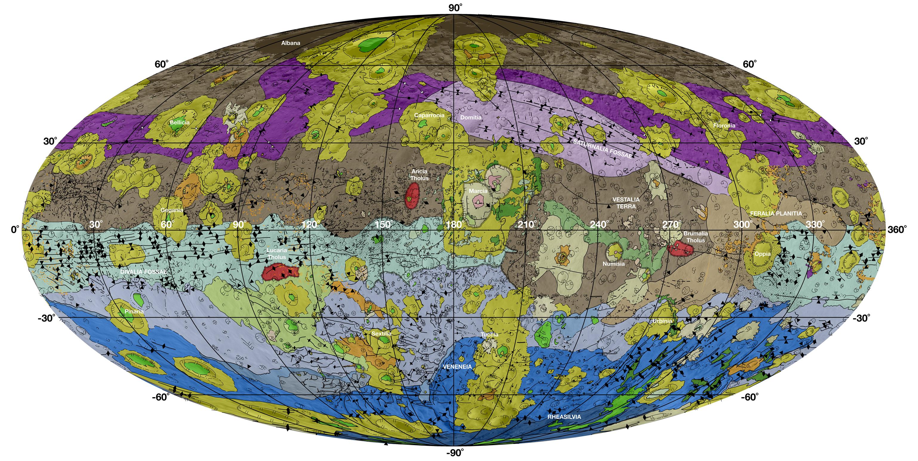
Description: Geological Map of Vesta November 17, 2014 http://www.jpl.nasa.gov/spaceimages/details.php?id=pia18788 http://www.jpl.nasa.gov/news/news.php?release=2014-399 This high-resolution geological map of Vesta is derived from Dawn spacecraft data. Brown colors represent the oldest, most heavily cratered surface. Purple colors in the north and light blue represent terrains modified by the Veneneia and Rheasilvia impacts, respectively. Light purples and dark blue colors below the equator represent the interior of the Rheasilvia and Veneneia basins. Greens and yellows represent relatively young landslides or other downhill movement and crater impact materials, respectively. This map unifies 15 individual quadrangle maps published this week in a special issue of Icarus. Map is a Mollweide projection, centered on 180 degrees longitude using the Dawn Claudia coordinate system. JPL manages the Dawn mission for NASA's Science Mission Directorate in Washington. Dawn is a project of the directorate's Discovery Program, managed by NASA's Marshall Space Flight Center in Huntsville, Alabama. The University of California at Los Angeles (UCLA) is responsible for overall Dawn mission science. Orbital Sciences Corp. in Dulles, Virginia, designed and built the spacecraft. The German Aerospace Center, the Max Planck Institute for Solar System Research, the Italian Space Agency and the Italian National Astrophysical Institute are international partners on the mission team. More information about Dawn is online at http://www.nasa.gov/dawn.
Title: PIA18788-VestaAsteroid-GeologicMap-DawnMission-20141117
Credit: http://photojournal.jpl.nasa.gov/jpeg/PIA18788.jpg
Author: NASA/JPL-Caltech/ASU
Usage Terms: Public domain
License: Public domain
Attribution Required?: No
Image usage
The following page links to this image:
