
Image: Plan of Yerevan 1920
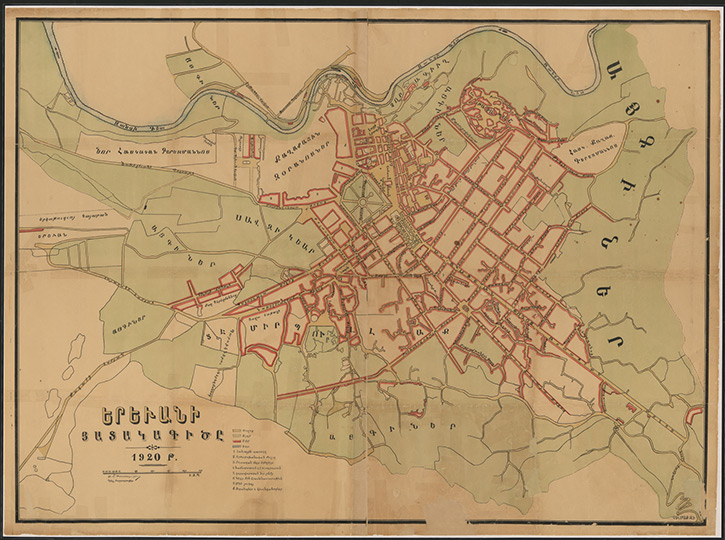
Description: The modern city of Yerevan dates its origins to the founding of the Urartean fortress of Erebuni in 782 BC. It has been inhabited continuously ever since, and its citizens delight in pointing out that their city is older than Rome. Yerevan, however, remained a relatively small city until after the Russian conquest of the Caucasus in the early nineteenth century. It later became the capital of the short-lived First Armenian Republic, the first independent state of Armenia since the fall of the Cilician Kingdom of Armenia in AD 1375. The country was created on May 28, 1918, out of the chaos that followed the end of World War I, and lasted until late November–early December 1920. This large-scale map of Yerevan was probably published by the government of the Democratic Republic of Armenia before the Bolshevik takeover. Երեւանի յատակագիծը (Plan of Yerevan). Yerevan: probably Democratic Republic of Armenia, 1920. Geography and Map Division, Library of Congress (061.00.01)
Title: Plan of Yerevan 1920
Credit: http://myloc.gov/Exhibitions/armenian-literary-tradition/exhibition-items/ExhibitObjects/Yerevan-First-Republic-Of-Armenia.aspx
Author: probably Democratic Republic of Armenia, 1920. Geography and Map Division, Library of Congress (061.00.01)
Usage Terms: Public domain
License: Public domain
Attribution Required?: No
Image usage
The following page links to this image:
