
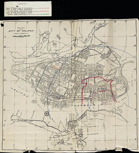
Image: Plan of the City of Halifax, Nova Scotia, showing the radius of the blast from the explosion - Plan de la cite d’Halifax en Nouvelle-Écosse, montrant l’étendue du souffle de l’explosion (8148373492)

Description: Title / Titre : Plan of the City of Halifax, Nova Scotia, showing the radius of the blast from the explosion / Plan de la cite d’Halifax en Nouvelle-Écosse, montrant l’étendue du souffle de l’explosion Creator(s) / Créateur(s) : Royal Society of Canada Date(s) : circa / vers 1916 Reference No. / Numéro de référence : MIKAN 165552 collectionscanada.gc.ca/ourl/res.php?url_ver=Z39.88-2004&... Location / Lieu : Halifax, Nova Scotia, Canada / Halifax, Nouvelle-Écosse, Canada Credit / Mention de source : Royal Society of Canada. Canada. Department of National Defence. Library and Archives Canada, e000000569 / Royal Society of Canada. Canada. Ministère de la défense nationale. Bibliothèque et Archives Canada, e000000569
Title: Plan of the City of Halifax, Nova Scotia, showing the radius of the blast from the explosion - Plan de la cite d’Halifax en Nouvelle-Écosse, montrant l’étendue du souffle de l’explosion (8148373492)
Credit: Plan of the City of Halifax, Nova Scotia, showing the radius of the blast from the explosion / Plan de la cite d’Halifax en Nouvelle-Écosse, montrant l’étendue du souffle de l’explosion
Author: BiblioArchives / LibraryArchives from Canada
Usage Terms: Creative Commons Attribution 2.0
License: CC BY 2.0
License Link: https://creativecommons.org/licenses/by/2.0
Attribution Required?: Yes
Image usage
The following page links to this image:

.jpg)