
Image: Pleasant Hill Battlefield Louisiana

Size of this preview: 455 × 599 pixels. Other resolutions: 182 × 240 pixels | 1,420 × 1,870 pixels.
Original image (1,420 × 1,870 pixels, file size: 1,011 KB, MIME type: image/jpeg)
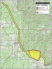
Description: Map of battlefield core and study areas. The revised Study Area includes the Confederate route of advance from the Mansfield battlefield, where the two armies had fought the previous day, to the vicinity of the Federal position at Pleasant Hill. The Study Area also includes the route of the Federal retreat towards Grand Ecore as the battle ended. The Core Area was widened to the north and south to include land over which the Confederates attempted flanking manouevres against the Federal left.
Title: Pleasant Hill Battlefield Louisiana
Credit: National Park Service
Author: American Battlefield Protection Program
Usage Terms: Public domain
License: Public domain
Attribution Required?: No
Image usage
The following page links to this image:

All content from Kiddle encyclopedia articles (including the article images and facts) can be freely used under Attribution-ShareAlike license, unless stated otherwise.