
Image: Port Hudson End

Size of this preview: 364 × 600 pixels. Other resolutions: 145 × 240 pixels | 2,670 × 4,400 pixels.
Original image (2,670 × 4,400 pixels, file size: 5.56 MB, MIME type: image/jpeg)
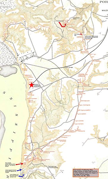
Description: Map from the Official Military Atlas of the Civil War, Plate 38, edited to highlight the final stages of the siege of Port Hudson, Louisiana, 1863, edited with Inkscape.
Title: Port Hudson End
Credit: U.S. Army Military History Institute
Author: Frank (talk) 21:16, 22 March 2011 (UTC)
Permission: Work of the United States Army
Usage Terms: Public domain
License: PD
Attribution Required?: No
Image usage
The following page links to this image:

All content from Kiddle encyclopedia articles (including the article images and facts) can be freely used under Attribution-ShareAlike license, unless stated otherwise.