
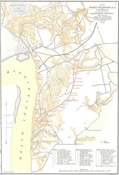
Image: Port Hudson Map 1864

Size of this preview: 408 × 600 pixels. Other resolutions: 163 × 240 pixels | 4,063 × 5,975 pixels.
Original image (4,063 × 5,975 pixels, file size: 1.39 MB, MIME type: image/jpeg)
Description: Port Hudson Map and Vicinity, Prepared by order of Major General N.P. Banks under direction of Major D. C. Houston, Corps of Engineers, 1864
Title: Port Hudson Map 1864
Credit: Official Military Atlas of the Civil War, U.S. Army Military History Institute, 1983
Author: Frank (talk) 20:34, 5 June 2010 (UTC)
Permission: Work of the U.S. Army Military History Institute
Usage Terms: Public domain
License: PD
Attribution Required?: No
Image usage
The following page links to this image:

All content from Kiddle encyclopedia articles (including the article images and facts) can be freely used under Attribution-ShareAlike license, unless stated otherwise.