
Image: Possible definitions of the boundary between Europe and Asia
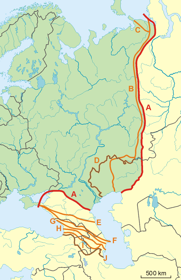
Description: A map of possible definitions of the boundary between Europe and Asia. Note that most of these lines are not referenced to any sources proposing them. The red line marked "A" is apparently the "Strahlenberg" definition commononly taught in Soviet-era Russia. See File:Historical Europe-Asia boundaries 1700 to 1900.png for a map which is actually based on references.
The modern mainstream definition used by the UN (see also this) are marked "B" (Urals and Ural River) and "F" (Caucasus watershed).
Lines C, D, E, G, H, I and J are currently without reference.
Red line - "Strahlenberg" border, allegedly also used by the International Geographical Union [1]
A: Ural Mountains-Emba River and Kuma Manych Depression (at Rivers Kuma, Manych and lower Don)
Orange lines - other variants of border:
B: Ural Mountains-Ural River (modern mainstream definition)
C: Yugorsky Strait Cape–Pay Khoy Mountains–Ural Mountains-Ural River
D: Ural Mountains-Kazakhstan Border
E: northern foothills of Caucasus
F: Lines on the Great Caucasus watershed (modern mainstream definition)
G: southern foothills of Caucasus
H: Meso-Caucasus at Rivers Rioni and Kura
I: Lines on the Lesser Caucasus and Rivers Araks and Kura
J: former Soviet Union border
Author: Aotearoa
Usage Terms: Creative Commons Attribution-Share Alike 3.0
License: CC-BY-SA-3.0
License Link: http://creativecommons.org/licenses/by-sa/3.0/
Attribution Required?: Yes
Image usage
The following page links to this image:
