
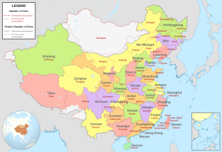
Image: ROC vs PRC

Description: Comparison between Republic of China (1953-2002 in Taiwan) and People's Republic of China administrative divisions. Grey lines are political boundaries drawn by the PRC. The formal names of these political entities are in black text. Red lines are political boundaries drawn by the ROC between 1953[1] and 2002[2]. The formal names of these political entities are in red text. Areas between red and grey lines (international boundaries) represent the territories claimed by the ROC before 2002 but not the PRC.Adapted from File:ROC PRC comparison eng.jpg. The original ROC map included more cities, but the adaptation removed non-central municipalities to clean up the image. Therefore, this image contains: Republic of China
35 provinces 12 Mainland municipalities + 6 Taiwanese municipalities 2 areas (Mongolia and Tibet) 1 special administrative region (Hainan)People's Republic of China
23 provinces 4 municipalities 5 autonomous regions 2 special administrative regions (Hong Kong and Macau)
Author: Milenioscuro
Usage Terms: Creative Commons Attribution-Share Alike 3.0
License: CC-BY-SA-3.0
License Link: http://creativecommons.org/licenses/by-sa/3.0/
Attribution Required?: Yes
Image usage
The following page links to this image:
