
Image: Radar loop of Typhoon Haiyan (Yolanda) making landfall on Leyte Island

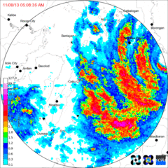
Description: Loop of doppler radar imagery showing Typhoon Yolanda/Haiyan's second Philippine landfall, on the island of Leyte. The PAGASA Cebu City radar site began to transmit intermittently as the typhoon neared, eventually failing altogether (last frame). 5:08AM - The northern eye of Haiyan making landfall on the village of Guiuan, which blows the dome off Guiuan radar station. Crosses into the Leyte Gulf shortly thereafter. 7:00AM - Landfall on the island of Leyte. The northern eyewall, the most powerful part of the storm, hits Tacloban City. 8:06AM - Northern portion of Haiyan's central core collapses while crossing over Leyte's Nacolod mountain range, though still remaining a category 5 storm. Eye overhead of Ormoc City. 9:33AM - Haiyan on the Cebu Strait, immediately before making landfall on the island of Cebu.
Title: Radar loop of Typhoon Haiyan (Yolanda) making landfall on Leyte Island
Credit: http://www.pagasa.dost.gov.ph/
Author: PAGASA
Usage Terms: Public domain
License: Public domain
Attribution Required?: No
Image usage
The following page links to this image:

_making_landfall_on_Leyte_Island.gif)