
Image: Raritanrivermap
No higher resolution available.
Raritanrivermap.png (300 × 300 pixels, file size: 17 KB, MIME type: image/png)
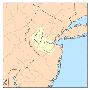
Description: This is a map of the Raritan river watershed. Rivers shown are the north and south branches of the Raritan river and the Millstone river. I, Karl Musser, created it based on USGS data.
Title: Raritanrivermap
Credit: No machine-readable source provided. Own work assumed (based on copyright claims).
Author: No machine-readable author provided. Kmusser assumed (based on copyright claims).
Usage Terms: Creative Commons Attribution-Share Alike 2.5
License: CC BY-SA 2.5
License Link: http://creativecommons.org/licenses/by-sa/2.5
Attribution Required?: Yes
Image usage
The following 2 pages link to this image:

All content from Kiddle encyclopedia articles (including the article images and facts) can be freely used under Attribution-ShareAlike license, unless stated otherwise.