
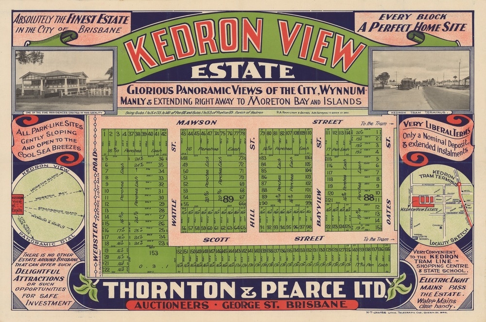
Image: Real estate map of Kedron View Estate, Brisbane, ca. 1914 (25795153793)
Description: Creator: Thornton & Pearce Ltd., Auctioneers ; R.A. Hamilton & James, Surveyors. Location: Stafford Heights, Brisbane, Queensland. Description: Estate covers area now in Kedron and Stafford Heights. Plan of allotments to be sold. Land for sale is subdivision 1 to 15 and 135 to 140 of portion 88 and subdivisions 1 to 153 of portion 89. Parish of Kedron. Includes 2 b&w photographs of area. Published by H.T. James lithographer (Brisbane). 48 x 72 cm. Map includes conditions of purchase, locality map, 2 b&w photographs and a brief description of the land and utlities available. Read more about SLQ's map collections: http://blogs.slq.qld.gov.au/?s=maps View this image at the State Library of Queensland: http://hdl.handle.net/10462/deriv/253240 Information about State Library of Queensland’s collection: http://www.slq.qld.gov.au/resources/picture-queensland You are free to use this image without permission. Please attribute State Library of Queensland.
Title: Real estate map of Kedron View Estate, Brisbane, ca. 1914 (25795153793)
Credit: https://www.flickr.com/photos/statelibraryqueensland/25795153793/
Author: State Library of Queensland, Australia
Permission: At the time of upload, the image license was automatically confirmed using the Flickr API. For more information see Flickr API detail.
Usage Terms: No known copyright restrictions
License: No restrictions
License Link: https://www.flickr.com/commons/usage/
Attribution Required?: No
Image usage
The following 2 pages link to this image:

.jpg)