
Image: Roman Empire 125

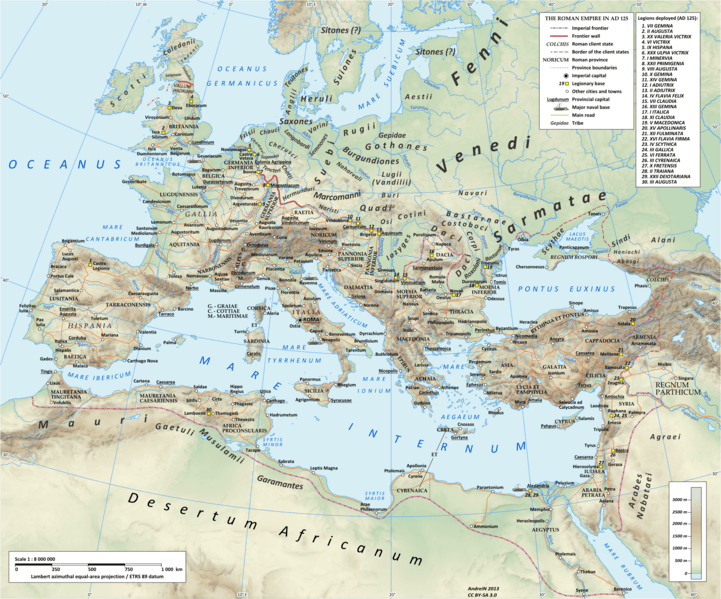
Description: Map of the Roman Empire in 125 during the reign of emperor Hadrian. Projection Lambert azimuthal-equal area. Central latitude: 45° N, central longitude: 20° E. X, Y origin offset - 0 Datum: ETRS89 Sources The physical map was made using the following public domain sources: Topography: NASA Shuttle Radar Topography Mission (SRTM30) data Shoreline, lakes and rivers: derived from Natural Earth data Additional references for the map content: Tacitus, Germania (ca. 100) Ptolemy, Geographia (ca. 140) Atlante storico DeAgostini, Instituto Geografico DeAgostini, 1998. pg. 35-41. Historischer Weltatlas, Dr. Walter Leisering, Marix Verlag, 2011. pg. 26-27 Történelmi világatlasz, Cartographia Kiadó, 2005. pg. 20-21. The Penguin Historical Atlas of Ancient Rome by Christopher Scarre, Penguin Historical Atlases, 1995. pg. 81. Software used GIS: Open JUMP GIS (open source): http://www.openjump.org/ GRASS GIS (open source): http://grass.osgeo.org/ Graphics editors: Inkscape (open source): http://inkscape.org/ GIMP (open source): http://www.gimp.org/
Title: Roman Empire 125
Credit: Own work
Author: User:Andrein
Permission: Any use of this map can be made as long as you credit the author, Andrei N. (Wikipedia Commons user Andrein), and distribute the copies and derivative works under the same license as that the one stated below.
Usage Terms: Creative Commons Attribution-Share Alike 3.0
License: CC BY-SA 3.0
License Link: http://creativecommons.org/licenses/by-sa/3.0
Attribution Required?: Yes
Image usage
The following 27 pages link to this image:
- Africa Province
- Alans
- Burgundians
- Gallia Belgica
- Gepids
- Goths
- Hadrian
- Judea (Roman province)
- Legio II Augusta
- Legio IX Hispana
- Legio VII Claudia
- Legio VI Victrix
- Legio XIV Gemina
- Legio XX Valeria Victrix
- Legio X Gemina
- Lugii
- Marcomanni
- Mauretania Tingitana
- Mauri
- Nerva-Antonine dynasty
- Roman legion
- Roxolani
- Sardinia and Corsica
- Sarmatians
- Saxons
- Vandal
- Vandals
