
Image: Route of the Expedition A. D. 1825, from Fort William to the Saskatchewan River (1828)

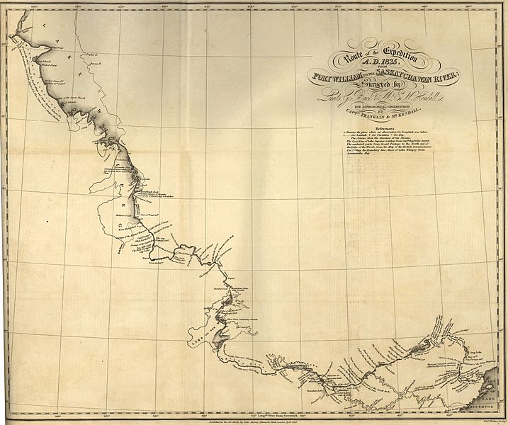
Description: Franklin, John. Route of the Expedition A. D. 1825, from Fort William to the Saskatchewan River [map]. Scale not given. In: John Franklin. Narrative of a Second Expedition to the Shores of the Polar Sea in the Years 1825, 1826, and 1827. London: John Murray, 1828. Surveyed by G. Back & Mr. E. N. Kendall; The Astronomical Observations by Captn. Franklin & Mr. Kendall. Shows the places where an Observation for Latitude was taken. The Coast Line of Lake Superior is taken from Captn. Bayfields Survey. The unshaded parts from Grand Portage to the North end of the Lake of the Woods, from the map of the British Commissioners for settling the Boundary line; those of Lake Winnipeg from Arrowsmith’s Map. Captain John Franklin’s two land expeditions to the Arctic traveled through the area which today is Manitoba, and added substantially to the scientific knowledge of both the northern and southern parts of the province. Progress of the expedition can be easily followed since all the camping places are marked. In 1825 Franklin’s party traveled via New York, the Great lakes, Lake of the Woods and the Winnipeg River to the Arctic. Detailed comments on the rocks observed appear on the map, including the identification of the limestone on the west side of Lake Winnipeg as “Mountain Limestone”. On these maps we see the first results of the application of scientific knowledge by experienced scientific observers to the recording of data on the West. The base maps were from Arrowsmith, but in turn Arrowsmith and other cartographers obtained important information from the Franklin’s Expeditions. (Warkentin and Ruggles. Historical Atlas of Manitoba. map 82, p. 206) Image Courtesy of University of Manitoba : Archives & Special Collections
Title: Route of the Expedition A. D. 1825, from Fort William to the Saskatchewan River (1828)
Credit: Route of the Expedition A. D. 1825, from Fort William to the Saskatchewan River (1828)
Author: Manitoba Historical Maps
Usage Terms: Creative Commons Attribution 2.0
License: CC BY 2.0
License Link: https://creativecommons.org/licenses/by/2.0
Attribution Required?: Yes
Image usage
The following page links to this image:

.jpg)