
Image: Rust-belt-map
No higher resolution available.
Rust-belt-map.jpg (280 × 183 pixels, file size: 19 KB, MIME type: image/jpeg)
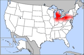
Description: New Castle and the nearby "Iron City" (Pittsburgh) are both nearly dead center in the red scatter diagram of the Rust Belt on this map showing the continental USA. The Rust Belt is highlighted on the above map in red. Manufacturing Belt, highlighted in red. Rust Belt, highlighted in red.
Title: Rust-belt-map
Credit: http://en.wikipedia.org/wiki/Image:Rust-belt-map.jpg#file
Usage Terms: Creative Commons Attribution-Share Alike 3.0
License: CC-BY-SA-3.0
License Link: http://creativecommons.org/licenses/by-sa/3.0/
Attribution Required?: Yes
Image usage
The following 2 pages link to this image:

All content from Kiddle encyclopedia articles (including the article images and facts) can be freely used under Attribution-ShareAlike license, unless stated otherwise.