
Image: Rustamid territory 9th century

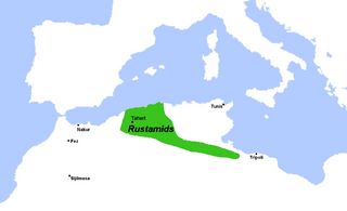
Description: Map of approximate Rustamid territory in the 9th century. Sources: Map is directly based on Figure 4.6 in Rushword, Alan (2017), "From Arzuges to Rustamids: State Formation and Regional Identity in the Pre-Saharan Zone" in Merrills, Andrew (ed.) Vandals, Romans and Berbers: New Perspectives on Late Antique North Africa (see Google preview here; page number not available in this format). That map is based in turn on the map in Abun-Nasr, Jamil (1987) A history of the Maghrib in the Islamid Period, p.44, which also specifies the time-frame as "9th century". The Commons file entitled "خريطة الدولة الرستمية.jpg", by user Zakaria El Sanhadji, was used to create a blank template, onto which the territory and the cities were added from the sources above
Title: Rustamid territory 9th century
Credit: Own work
Author: R Prazeres
Usage Terms: Creative Commons Attribution-Share Alike 4.0
License: CC BY-SA 4.0
License Link: https://creativecommons.org/licenses/by-sa/4.0
Attribution Required?: Yes
Image usage
The following page links to this image:
