
Image: Ruysch map, Gruenlant-Antilia

Size of this preview: 600 × 600 pixels. Other resolutions: 240 × 240 pixels | 1,500 × 1,500 pixels.
Original image (1,500 × 1,500 pixels, file size: 861 KB, MIME type: image/jpeg)
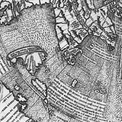
Description: Close up of the Ruysch map (1507) showing Gruenlant, Antilia, Cuba, and the coast of South America
Title: Ruysch map, Gruenlant-Antilia
Credit: scanned from Thomas Suárez, Shedding the Veil
Author: Johann Ruysch († 1533), scanned by Kimon Berlin, user:Gribeco
Permission: reproduction of public domain work
Usage Terms: Public domain
License: Public domain
Attribution Required?: No
Image usage
The following 2 pages link to this image:

All content from Kiddle encyclopedia articles (including the article images and facts) can be freely used under Attribution-ShareAlike license, unless stated otherwise.