
Image: SA-Election2018-adelaide-map

Size of this preview: 535 × 600 pixels. Other resolutions: 214 × 240 pixels | 1,853 × 2,078 pixels.
Original image (1,853 × 2,078 pixels, file size: 310 KB, MIME type: image/png)
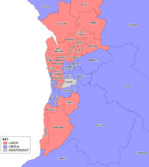
Description: Map of electoral districts in the Adelaide metropolitan area, coloured to represent the party winning the seat at the 2014 South Australian state election and changes since.
Title: SA-Election2018-adelaide-map
Credit: Own work. Uses data from data.sa
Author: Canley
Usage Terms: Creative Commons Attribution-Share Alike 3.0
License: CC BY-SA 3.0
License Link: http://creativecommons.org/licenses/by-sa/3.0
Attribution Required?: Yes
Image usage
The following page links to this image:

All content from Kiddle encyclopedia articles (including the article images and facts) can be freely used under Attribution-ShareAlike license, unless stated otherwise.