
Image: SA-Election2018-state-map

Size of this preview: 429 × 600 pixels. Other resolutions: 172 × 240 pixels | 1,889 × 2,641 pixels.
Original image (1,889 × 2,641 pixels, file size: 266 KB, MIME type: image/png)
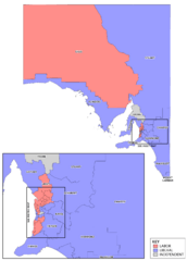
Description: Map of electoral districts in the state of South Australia, coloured to represent the party winning the seat at the 2014 South Australian state election and changes since. Inset to Metro map refers to File:SA-Election2014-adelaide-map.png.
Title: SA-Election2018-state-map
Credit: Own work. Uses data from data.sa
Author: Canley
Usage Terms: Creative Commons Attribution-Share Alike 3.0
License: CC BY-SA 3.0
License Link: http://creativecommons.org/licenses/by-sa/3.0
Attribution Required?: Yes
Image usage
The following page links to this image:

All content from Kiddle encyclopedia articles (including the article images and facts) can be freely used under Attribution-ShareAlike license, unless stated otherwise.