
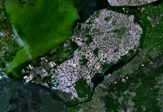
Image: Satellite image of Flevopolder, Netherlands (5.48E 52.43N)

Size of this preview: 800 × 548 pixels. Other resolutions: 320 × 219 pixels | 1,024 × 702 pixels.
Original image (1,024 × 702 pixels, file size: 1.49 MB, MIME type: image/png)
Description: Satellite image of the Flevopolder in the Netherlands. Technically, the Flevopolder consists of Zuidelijk Flevoland (Southern Flevoland), Oostelijk Flevoland (Eastern Flevoland) and the Noordoostpolder (North Eastern Polder). This image shows Southern and Eastern Flevoland.
Title: Satellite image of Flevopolder, Netherlands (5.48E 52.43N)
Credit: Screenshot from NASA's World Wind
Usage Terms: Public domain
License: Public domain
Attribution Required?: No
Image usage
The following 2 pages link to this image:

All content from Kiddle encyclopedia articles (including the article images and facts) can be freely used under Attribution-ShareAlike license, unless stated otherwise.
.png)