
Image: South Australia cadastral divisions 1886

Size of this preview: 526 × 599 pixels. Other resolutions: 211 × 240 pixels | 1,000 × 1,139 pixels.
Original image (1,000 × 1,139 pixels, file size: 117 KB, MIME type: image/png)
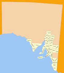
Description: 37 counties of South Australia in 1886, based on public domain old map in National Library collection. They are used only for cadastral purposes today, but there are several more added (now 49) - they still do not cover the whole state though. See also: 1893 map with 45 counties
Title: South Australia cadastral divisions 1886
Credit: No machine-readable source provided. Own work assumed (based on copyright claims).
Author: No machine-readable author provided. Roke~commonswiki assumed (based on copyright claims).
Usage Terms: Creative Commons Attribution-Share Alike 3.0
License: CC-BY-SA-3.0
License Link: http://creativecommons.org/licenses/by-sa/3.0/
Attribution Required?: Yes
Image usage
The following page links to this image:

All content from Kiddle encyclopedia articles (including the article images and facts) can be freely used under Attribution-ShareAlike license, unless stated otherwise.