
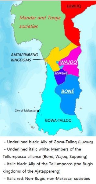
Image: South Sulawesi between Gowa and the Tellumpocco

Description: A geopolitical map depicting South Sulawesi around 1590, divided between Gowa-Talloq and the alliance of the Tellumpocco. Made with DEMIS World Map Server; data from Ian Caldwell's article "Power, State and Society Among the Pre-Islamic Bugis." Also shows the kingdoms of Wajoq (Wajo), Boné (Bone, Boni) and Soppeng.
Title: South Sulawesi between Gowa and the Tellumpocco
Credit: Own work
Author: Karaeng Matoaya
Permission: This image is in the public domain because it came from the site https://www.demis.nl/products/web-map-server/examples/ and was released by the copyright holder. Permission is granted to copy, distribute and/or modify this map since it is based on free of copyright images from: www.demis.nl. See also approval email on de.wp and its clarification.
Usage Terms: Public domain
License: Public domain
Attribution Required?: No
Image usage
The following 2 pages link to this image:
