
Image: Southwest Ecodistrict - National Capital Planning Commission - 2009

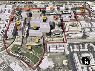
Description: Map of the boundaries of the Southwest Ecodistrict, an initiative of the U.S. National Capital Planning Commission which seeks to redevelop L'Enfant Plaza and its environs into a multi-modal mixed-use neighborhood of significant cultural attractions and public spaces, offices, residences, and amenities. Numbered circles on the map correspond to the following: 1 - U.S. Department of Energy/James V. Forrestal Complex 2 - Cotton Annex 3 - U.S. Postal Service headquarters 4 - Federal Aviation Administration headquarters 5 - Federal Aviation Administration headquarters 6 - General Services Administration 7 - U.S. Department of Housing and Urban Development (Robert C. Weaver Federal Building) 8 - U.S. Department of Education 9 - 12th Street Tunnel 10 - CSX Rail Line/Maryland Avenue SW 11 - Southwest Freeway (Interstate 395) 12 - 10th Street Overlook/Benjamin Banneker Park 13 - L'Enfant Plaza
Title: Southwest Ecodistrict - National Capital Planning Commission - 2009
Credit: http://www.ncpc.gov/DocumentDepot/Planning/SWEcodistrictInfoSheet.pdf
Author: U.S. National Capital Planning Commission
Usage Terms: Public domain
License: Public domain
Attribution Required?: No
Image usage
The following page links to this image:
