
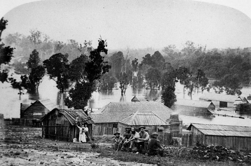
Image: StateLibQld 1 159247 Floods in the Gympie area in 1870

Description: Floods in the Gympie area in 1870. Gympie residents head for higher ground during the flooding in 1870. The photograph shows slab dwellings and bark-roofed huts. Gympie is a city in south-eastern Queensland, situated on the Mary River about 162 kilometres north of Brisbane. Gympie is the centre of an important dairying and agricultural district. In the early days timber was a significant industry. In 1867 James Nash found nuggets of gold in the bed of a dry gully in the district and a spectacular gold rush commenced. Gympie was originally called Nashville after the discoverer of the gold. In 1868 the name was altered to Gympie, an aboriginal term for the stinging trees found in the district. The discovery of gold proved the salvation of Queensland as, at that time, the colony was passing through financial difficulties. The largest mine was the Scottish Gympie which worked at levels from 650 to over 800 metres deep, and had underground roadways exceeding 50 kilometres in length. In 1909 fifty-one mining companies were operating. A huge nugget of pure gold, called the Curtis nugget was found in the Gympie district. It contained 906 ozs. of Gold. The mining of gold petered out in the 1920's. (Information taken from: The Australian Encyclopaedia and Explore Australia, 2003, Sydney Australia, Penguin Australia.
Title: StateLibQld 1 159247 Floods in the Gympie area in 1870
Credit: Item is held by John Oxley Library, State Library of Queensland.
Author: Mathewson
Usage Terms: Public domain
License: Public domain
Attribution Required?: No
Image usage
The following page links to this image:
