
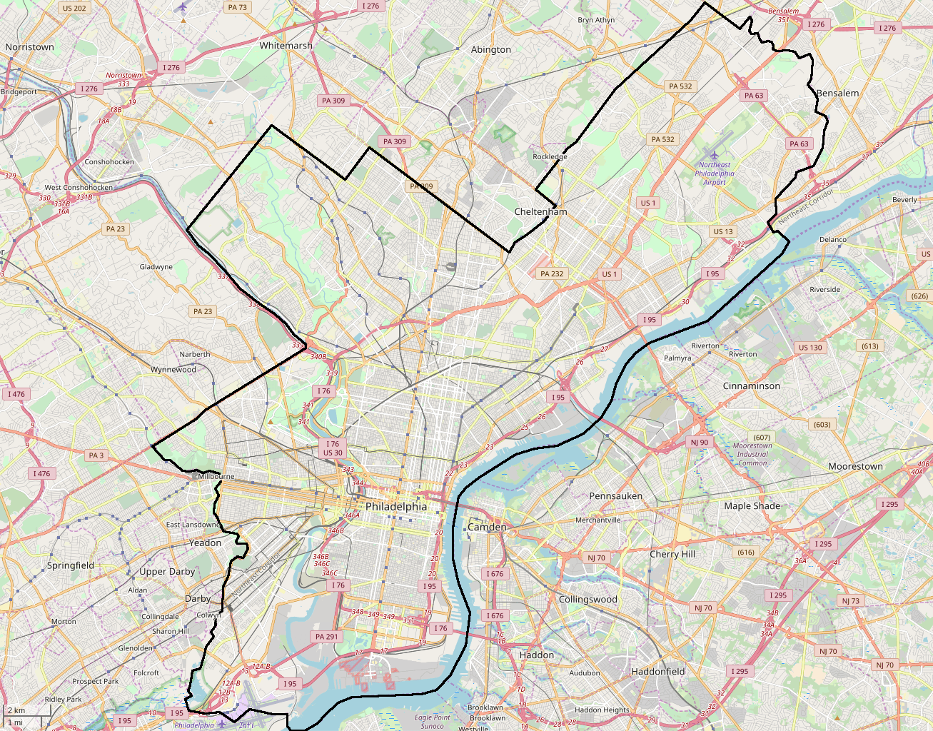
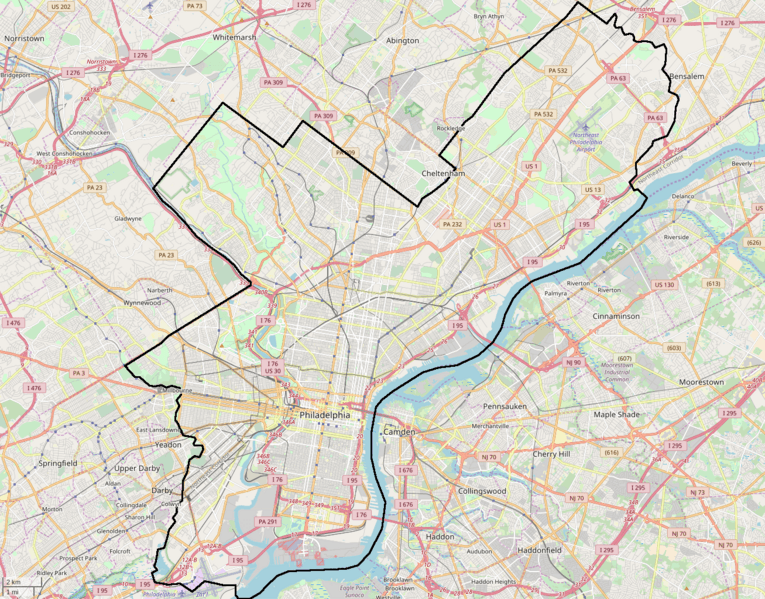
Image: Street map of Philadelphia and surrounding area
Description: Street map of Philadelphia and surrounding area copied from the Openstreetmap.org website by changing to fullscreen mode (F11), zooming until the city just filled the screen, then pressing the "print screen" key to save a 1920x1080 image. Top banner was cropped off. Cropped left and right sides to approximately a 1.276 aspect ratio, to focus on the city and to increase thumbnail image sizes. Slightly increased contrast and reduced brightness. Added a black line along the city boundaries. Added "Philadelphia Int'l" text by the airport. Removed some partial highway markers near left and right edges which were distracting and unnecessary.
Title: Street map of Philadelphia and surrounding area
Credit: openstreetmap.org
Author: OpenStreetMap contributors
Permission: OpenStreetMap data is available under the Open Database License (details). Map tiles are licensed under the Creative Commons Attribution-ShareAlike 2.0 license (CC-BY-SA 2.0). Contains map data © OpenStreetMap contributors, made available under the terms of the Open Database License (ODbL). The ODbL does not require any particular license for maps produced from ODbL data; map tiles produced by the OpenStreetMap foundation are licensed under the CC-BY-SA-2.0 licence, but maps produced by other people may be subject to other licences.Open Database LicenseODbLhttp://opendatacommons.org/licenses/odbl/1.0/true This file is licensed under the Creative Commons Attribution-Share Alike 2.0 Generic license. You are free: to share – to copy, distribute and transmit the work to remix – to adapt the work Under the following conditions: attribution – You must give appropriate credit, provide a link to the license, and indicate if changes were made. You may do so in any reasonable manner, but not in any way that suggests the licensor endorses you or your use. share alike – If you remix, transform, or build upon the material, you must distribute your contributions under the same or compatible license as the original. https://creativecommons.org/licenses/by-sa/2.0 CC BY-SA 2.0 Creative Commons Attribution-Share Alike 2.0 truetrue
Usage Terms: Creative Commons Attribution-Share Alike 2.0
License: CC BY-SA 2.0
License Link: https://creativecommons.org/licenses/by-sa/2.0
Attribution Required?: Yes
Image usage
More than 100 pages link to this image. The following list shows the first 100 page links to this image only. A full list is available.
- 1616 Walnut Street Building
- 1900 Rittenhouse Square Apartments
- 26th District Police and Patrol Station
- A.J. Holman and Company building
- Academy at Palumbo
- All Wars Memorial to Colored Soldiers and Sailors
- Amalgamated Center
- American Baptist Publication Society building
- American Railway Express Company Garage
- Arch Street Friends Meeting House
- Arch Street Presbyterian Church
- Avenue of the Arts (Philadelphia)
- Awbury Historic District
- Baptist Institute for Christian Workers
- Beatty's Mills Factory Building
- Belfield (Philadelphia)
- Bell Telephone Company Building (Philadelphia)
- Belmont Village, Philadelphia
- Beth Sholom Congregation (Elkins Park, Pennsylvania)
- Bethel Burial Ground
- Boekel Building
- Brewerytown, Philadelphia
- Broad Street Historic District (Philadelphia)
- Bryn Mawr, Pennsylvania
- Budd Company
- Burk Brothers and Company
- Callowhill Industrial Historic District
- Camptown Historic District
- Cathedral Basilica of Saints Peter and Paul (Philadelphia)
- Cedar Grove Christian Academy
- Cedar Grove Mansion
- Chateau Crillon Apartment House
- Chinatown, Philadelphia
- Christ Church Burial Ground
- Church of the Advocate
- Church of the Holy Trinity, Philadelphia
- City Line Avenue Bridge
- City Park Brewery
- Clark Park
- Class and Nachod Brewery
- Cobbs Creek, Philadelphia
- Crescentville, Philadelphia
- Curtis Hall Arboretum
- Devil's Pocket, Philadelphia
- Dobson Mills
- Drake Hotel (Philadelphia)
- Druim Moir Historic District
- Ebenezer Maxwell House
- Edgar Allan Poe National Historic Site
- Edward Drinker Cope House
- Edwin Forrest House
- Elfreth's Alley
- Equestrian statue of Ulysses S. Grant
- Equitable Trust Building
- Fairhill, Philadelphia
- Fairmount Avenue Historic District
- Fairmount Park
- Fairmount Water Works
- Family Court Building
- First Unitarian Church of Philadelphia
- Fisher Fine Arts Library
- Fort Mifflin
- Fort Washington State Park
- Frances Ellen Watkins Harper House
- Frank C. Scherer Wagon Works
- Frankford Avenue Bridge
- Franklin Hose Company No. 28
- Franklin Learning Center
- Franklin Square (Philadelphia)
- Free Quaker Meetinghouse
- French Quarter, Philadelphia
- Garden Court, Philadelphia
- Germantown Cricket Club
- Germantown White House
- Glen Foerd on the Delaware
- Gloria Dei (Old Swedes') Church
- Greenbelt Knoll
- Grey Towers Castle
- Grumblethorpe
- Haddington, Philadelphia
- Henry O. Tanner House
- Henry S. Frank Memorial Synagogue
- Hill–Physick–Keith House
- Hog Island, Philadelphia
- Institute for Colored Youth
- Insurance Company of North America Building (Philadelphia)
- Italian Market, Philadelphia
- Jenkintown–Wyncote station
- Northern Liberties, Philadelphia
- Old City, Philadelphia
- Overbrook Farms, Philadelphia
- Parkside, Philadelphia
- Pennsylvania School for the Deaf
- Philadelphia Naval Asylum
- Powelton Village, Philadelphia
- Schuylkill, Philadelphia
- Somerton, Philadelphia
- Spring Garden, Philadelphia
- Suburban Station
- Washington Square West, Philadelphia
