
Image: Tachiraptor range map

Size of this preview: 800 × 468 pixels. Other resolutions: 320 × 187 pixels | 1,280 × 748 pixels.
Original image (1,280 × 748 pixels, file size: 70 KB, MIME type: image/jpeg)
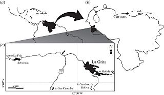
Description: Maps of (a) Venezuela within northern South and Central America, (b) Táchira State within Venezuela and (c) La Grita area indicating the location of the type locality of Tachiraptor admirabilis (black arrow). Dash-dotted lines denote main roads; thin dotted lines, paved secondary roads.
Title: Tachiraptor range map
Credit: New dinosaur (Theropoda, stem-Averostra) from the earliest Jurassic of the La Quinta formation, Venezuelan Andes
Author: Max C. Langer, Ascanio D. Rincón, Jahandar Ramezani, Andrés Solórzano, Oliver W. M. Rauhut
Usage Terms: Creative Commons Attribution 4.0
License: CC BY 4.0
License Link: https://creativecommons.org/licenses/by/4.0
Attribution Required?: Yes
Image usage
The following page links to this image:

All content from Kiddle encyclopedia articles (including the article images and facts) can be freely used under Attribution-ShareAlike license, unless stated otherwise.