
Image: Tamaulipan Mezquital Map

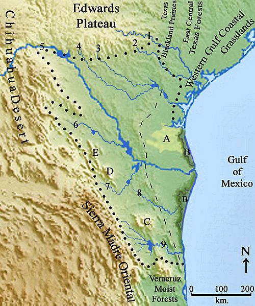
Description: This is a map illustrating the Tamaulipan biotic province of south Texas, USA and northeast Mexico, also referred to as the Tamaulipan mezquital by World Wildlife Fund. The border of the Tamaulipan biotic province are shown with the dotted line. The Bordas Escarpment is shown with dashed line, having deeper sandy soils to the east and high calcium soils over a thick layer of caliche to the west. Some major ecosystems in the region are identified with latters: A = Costal Sand Plains; B = Laguna Madre; C = Sierra San Carlos; D = Sierra Los Picachos; E = Sierra de Lampazos. The major rivers of the region are numbered: 1. Guadalupe River; 2. San Antonio River; 3. Frio River; 4. Nueces River; 5. Rio Grande / Rio Bravo; 6. Rio Salado/Rio Sabinas; 7. Rio San Juan; 8. Rio San Fernando; 9. Rio Soto La Marina. The Tamaulipan biotic province was identified and discussed in - Dice, L. R. 1943. The Biotic Provinces of North America. University of Michigan Press. Ann Arbor. Michigan. 1-78 pp. Blair, W. Frank. 1949 (1950).The Biotic Provinces of Texas.The Texas Journal of Science. Vol. 2, No. 1: 93-117.
Title: Tamaulipan Mezquital Map
Credit: Own work
Author: William L. Farr
Usage Terms: Creative Commons Attribution-Share Alike 4.0
License: CC BY-SA 4.0
License Link: https://creativecommons.org/licenses/by-sa/4.0
Attribution Required?: Yes
Image usage
The following page links to this image:
