
Image: Tectonic setting western Mexico

Size of this preview: 737 × 600 pixels. Other resolutions: 295 × 240 pixels | 1,929 × 1,570 pixels.
Original image (1,929 × 1,570 pixels, file size: 1.8 MB, MIME type: image/png)
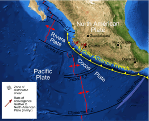
Description: Map of plate boundaries on the Pacific coast of western Mexico on a a base of a screenshot from Nasa World Wind software - boundaries taken from a variety of sources including Pardo & Suarez 1995, de Mets & Wilson 1997
Title: Tectonic setting western Mexico
Credit: Own work
Author: Mikenorton
Usage Terms: Creative Commons Attribution-Share Alike 3.0
License: CC BY-SA 3.0
License Link: https://creativecommons.org/licenses/by-sa/3.0
Attribution Required?: Yes
Image usage
The following page links to this image:

All content from Kiddle encyclopedia articles (including the article images and facts) can be freely used under Attribution-ShareAlike license, unless stated otherwise.