
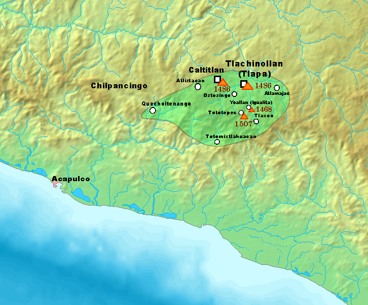
Image: Territorios de Tlachinollan a principios del siglo XVI
Description: A map depicting the aproximate borders of the Kingdom of Tlachinollan in the early 16th century, a Tlapanec kingdom in the territories of modern-day Guerrero, Mexico. The borders of Tlachinollan are depicted within the green area, and some of the military campaigns launched by the Mexica Empire in the area are depicted as well, along with their dates. Campaigns not shown in the map are: The conquest of Atlitepec (1493) The conquest of Xipetepec (1503-1509) The conquest of Acocozpan (1515) The conquest of Tetenanco (1515) The reconquest of Atlitepec (1515) Source: Vega Sosa, Constanza (1992). "The Annals of the Tlapanecs". Supplement to the Handbook of Middle American Indians 5: 42—48, 51. Austin: University of Texas Press.
Title: Territorios de Tlachinollan a principios del siglo XVI
Credit: Own work
Author: ErickTErick
Usage Terms: Creative Commons Attribution-Share Alike 4.0
License: CC BY-SA 4.0
License Link: https://creativecommons.org/licenses/by-sa/4.0
Attribution Required?: Yes
Image usage
The following page links to this image:
