
Image: TomMorrisesFeature-RHP414(Whole) (1)

Size of this preview: 398 × 600 pixels. Other resolutions: 159 × 240 pixels | 1,000 × 1,507 pixels.
Original image (1,000 × 1,507 pixels, file size: 1.01 MB, MIME type: image/jpeg)
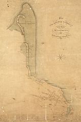
Description: Plan of the Golfing course over the links of St Andrews surveyed by order of the Royal St Andrews Golfing Society, Fife
Title: TomMorrisesFeature-RHP414(Whole) (1)
Credit: nrscotland.gov.uk
Author: National Records of Scotland
Usage Terms: Open Government License 3
License: OGL 3
License Link: http://www.nationalarchives.gov.uk/doc/open-government-licence/version/3
Attribution Required?: Yes
Image usage
The following page links to this image:

All content from Kiddle encyclopedia articles (including the article images and facts) can be freely used under Attribution-ShareAlike license, unless stated otherwise.
_(1).jpg)