
Image: USGS Oatman 1921 rfl01264

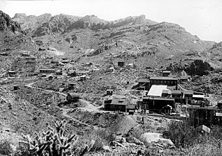
Description: Mines of the Oatman district; Up Gold Road Gulch, showing the surface relations of the Gold Road mine, right to left the following are identified; Gold Road Mill, No. 1 shaft, and No. 3 shaft. All the rock included in the view is the Gold Road latite. The generally easterly dip of the flows is distinctly shown. Mohave County, Arizona. 1921.
Title: USGS Oatman 1921 rfl01264
Credit: http://libraryphoto.cr.usgs.gov/cgi-bin/show_picture.cgi?ID=ID.%20Ransome,%20F.L.%201264
Author: USGS
Permission: This image is in the public domain in the United States because it only contains materials that originally came from the United States Geological Survey, an agency of the United States Department of the Interior. For more information, see the official USGS copyright policy. Български | Català | Čeština | Deutsch | English | Español | Eesti | فارسی | Suomi | Français | Galego | Italiano | 日本語 | 한국어 | Македонски | മലയാളം | Nederlands | Polski | Português | Русский | Sicilianu | Türkçe | 中文 | 中文(简体) | +/−
Usage Terms: Public domain
License: Public domain
Attribution Required?: No
Image usage
The following page links to this image:
