
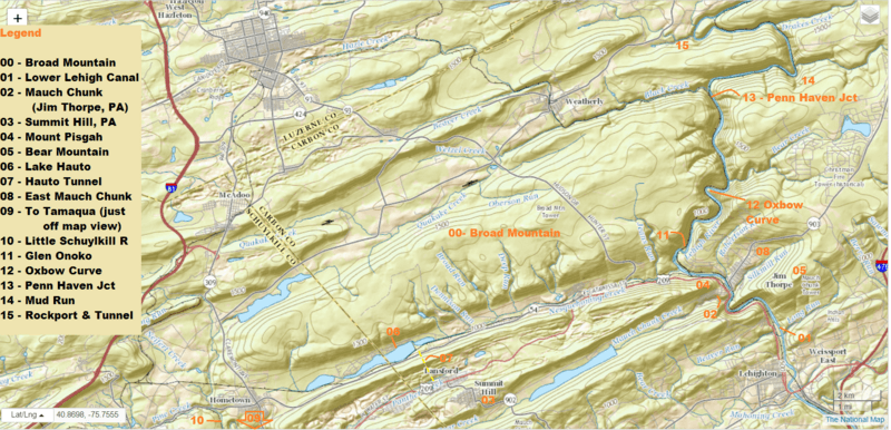
Image: USGS relief-Broad Mountain and Terrains it dominates west of the Lehigh Gorge and north of Tamaqua, Nesquehoning and Jim Thorpe, PA

Description: This is overview of the mountainous region dominated by Broad Mountain in Eastern Pennsylvania (Center of image, right bank of Lehigh River, below Weatherly, PA) illustrating its role historically as a barrier range limiting transportation corridors in the area; the heartland of the Southeastern Anthracite Coal Region. The regions along the lower edge of the Map (Tamaqua to Mauch Chunk) essentially established the Anthracite Industry in Pennsylvania when exploited by the Lehigh Coal & Navigation Company between 1818-1964. Railroads south from Tamaqua followed the Schuylkill Canal example and connected the center of the Southern Coal Region with That company, having established the Lehigh Canal (right side of map, the length of the Lehigh River shown and beyond to the North past the Lehigh Gorge) had something to do with virtually all the railways shown on the map, and many of those now absent. The North edge of Broad Mountain saw the construction of the Beaver Meadows Railroad (1832) along the middle part of the Lehigh & Susquehanna Turnpike (1804, 'Hudson Hunter Dr.', also now Pennsylvania Route 93) which allowed anthracite coal to be discovered and mined in the area, and mines opened from 1812, and which shipped by pack mules to smithies and foundries across the Susquehanna from Nescopeck, PA. West from the mouth of Quakake Creek the Quakake Railroad (1831) built west, as the Beaver Meadow Railroad (1833) built east to hook south at Penn Haven Junction and the deliver coal to the Lehigh Canal. This spur eventually became the Lehigh and Mahanoy Railroad division of the Lehigh Valley Railroad, as the Beaver Meadow became the Hazelton Branch of the LVRR. This commercial mining north of Broad Mountain was 6 years before Lehigh Coal Mine Company sold options to the Lehigh Coal & Navigation Company to mining rights to their site at Summit Hill. By 1820, LC&N Co.'s improvements allowed the first commercial shipment quantities that dwarfed pack mule capabilities when they shipped 365 tons in December of 1820, and increased that every year until 1855. Note the conspicuous absence of roads north-south on Broad Mountain. It is still an exemplar of a barrier range. This region is represented and well detailed in the USGS series topological maps grouped in Category:1893 maps of Pennsylvania.
Title: USGS relief-Broad Mountain and Terrains it dominates west of the Lehigh Gorge and north of Tamaqua, Nesquehoning and Jim Thorpe, PA
Credit: USGS screen capture: Via http://nationalmap.gov → http://viewer.nationalmap.gov where I navigated to area of view. Used Microsoft's Snipping Tool to capture when frame would not let image be saved by url.
Author: Annotations, general knowledge, by FrankB
Permission: CC-BY-SA-2.0 This image is in the public domain in the United States because it only contains materials that originally came from the United States Geological Survey, an agency of the United States Department of the Interior. For more information, see the official USGS copyright policy. Български | Català | Čeština | Deutsch | English | Español | Eesti | فارسی | Suomi | Français | Galego | Italiano | 日本語 | 한국어 | Македонски | മലയാളം | Nederlands | Polski | Português | Русский | Sicilianu | Türkçe | 中文 | 中文(简体) | +/−
Usage Terms: Public domain
License: Public domain
Attribution Required?: No
Image usage
The following 3 pages link to this image:
