
Image: Valentine Seaman's map of yellow fever epidemic in New York City (Plate 2 of 2)

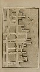
Description: In 1795, yellow fever broke out in New York City. At the time, it was not known how yellow fever spread; some blamed incoming ships from the tropics. As the fever spread, Seaman mapped each case he could find in the New Slip area, marking which cases were fatal. He then mapped local waste sites, compared the two maps, and concluded that yellow fever originated in these waste areas. (While he did note that mosquitoes were present at the waste sites, he did not identify them correctly as the vectors for the disease.) The city's Committee of Health asked for his advice regarding the disease's cause and prevention; Seaman recommended filling in areas that were below sea-level and wherever water tended to stagnate, cleaning and paving streets, covering sewers, and filling in the areas beneath granaries and docks. A fuller account and the maps he created (including this plate) were published in 'An Inquiry into the Cause of the Prevalence of the Yellow Fever in New-York' in 1798. The book this plate comes from belongs to the U.S. National Library of Medicine and was digitized with funding from the Open Knowledge Commons. It is hosted by the Internet Archive: https://archive.org/details/101290761.nlm.nih.gov
Title: Valentine Seaman's map of yellow fever epidemic in New York City (Plate 2 of 2)
Credit: An inquiry into the cause of the prevalence of the yellow fever in New-York [Plate I and Plate II, showing maps of the yellow fever epidemic in New York City in c. 1795] (published 1798)
Author: Valentine Seaman (author), James & Thomas Swords (printers)
Usage Terms: Public domain
License: Public domain
Attribution Required?: No
Image usage
The following page links to this image:

.jpg)