
Image: Virginia Central Map 1852 cropped

Size of this preview: 800 × 368 pixels. Other resolutions: 320 × 147 pixels | 1,425 × 655 pixels.
Original image (1,425 × 655 pixels, file size: 725 KB, MIME type: image/png)
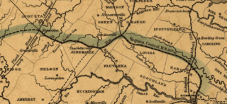
Description: An 1852 map showing the constructed portions of the Virginia Central Railroad. Cropped from original map.
Title: Virginia Central Map 1852 cropped
Credit: This map is available from the United States Library of Congress's Geography & Map Division under the digital ID g3881p.rr006010. This tag does not indicate the copyright status of the attached work. A normal copyright tag is still required. See Commons:Licensing for more information.
Author: Map created by W. Vaisz for the Virginia Central Railroad Company
Usage Terms: Public domain
License: Public domain
Attribution Required?: No
Image usage
The following 2 pages link to this image:

All content from Kiddle encyclopedia articles (including the article images and facts) can be freely used under Attribution-ShareAlike license, unless stated otherwise.