
Image: WW2-Holocaust-Europe

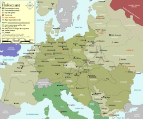
Description: Map of the Holocaust in Europe during World War II, 1939-1945. This map shows all German Nazi extermination camps (or death camps), most major concentration camps, labor camps, prison camps, ghettos, major deportation routes and major massacre sites. Notes: 1. Extermination camps were dedicated death camps, but all camps and ghettos took a toll of many, many lives. 2. Concentration camps include labor camps, prison camps & transit camps. 3. Not all camps & ghettos are shown. 4. Borders are at the height of Axis domination (1942). 5. Some regions have German designations (e.g. "Ostland"), with the present country name denoted in uppercase letters in parenthesis below the German designation (e.g. "(AUSTRIA)"). 6. Present (2007) borders are dotted.
Title: WW2-Holocaust-Europe
Credit: Self-made by User:Dna-Dennis, using information from USHMM & Wikipedia.
Author: User:Dna-Dennis
Permission: CC, see below. The map is completely unrestricted for any Wikipedia/Wikimedia project.
Usage Terms: Creative Commons Attribution 3.0
License: CC BY 3.0
License Link: http://creativecommons.org/licenses/by/3.0
Attribution Required?: Yes
Image usage
The following page links to this image:
