
Image: WW2-Holocaust-Poland
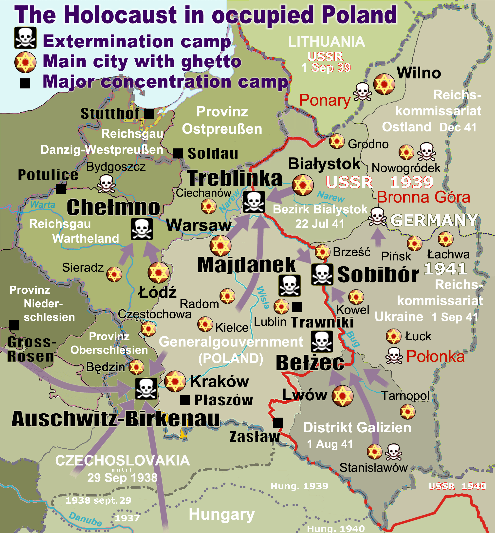
Description: Map of the Holocaust in occupied Poland during World War II. The outline shows the borders of the Second Polish Republic at the time of the Nazi-German-and-Soviet invasion of Poland in 1939 with demarcation line between the two invading armies marked in red. Internal boundaries show the administrative divisions of occupied territories imposed by Nazi Germany when the Final Solution was set in motion during and after Operation Barbarossa of 1941. This map shows all Nazi German extermination camps (or death camps), as well as prominent concentration, labour and prison camps, major pre-WW2 Polish cities with the new Jewish ghettos set up by Nazi Germany, major deportation routes, and major massacre sites. Notes: 1. Extermination camps – marked with white skulls in black squares – are six dedicated facilities used for the mass gassings of prisoners, but all camps and ghettos took a toll of many, many lives. 2. Concentration camps – marked with black squares – feature only the most notorious forced-labor camps, prison camps & transit camps. 3. Sites of mass shootings into remote ravines – marked with white skulls – include Bronna Góra, Ponary and others. They were utilized during the 'Holocaust by bullets'. 4. Destruction ghettos – marked with Yellow stars in red circles – existed in most Polish cities. Only a selection is shown. 5. Major deportation routes travelled by the Holocaust trains are marked with RosyBrown arrows. 6. Most camps & ghettos which are not well known have been excluded for clarity. 7. District borders are at the height of Axis domination (1942). 8. Regions have German designations (e.g. "Ostland"), with the country name denoted in uppercase letters, e.g. LITHUANIA, CZECHOSLOVAKIA, or in parenthesis below the German occupational designation, e.g. (POLAND).
Title: WW2-Holocaust-Poland
Credit: Own work. Composite map derived from a variety of readily available sources which may or may not include: http://www.wajszczuk.v.pl/z/wysiedleni/mapa02.jpg http://klaser.strefa.pl/zp/polska/mapy/on.gif http://portalhistoryczny.org/img/hist/pb2204.jpg http://www.dydaktycznepomoce.com/files/wojna%20obronna.jpg WW2-Holocaust-Europe.png, File:Polska okupacja 1944.png, Nazi Policy, Jewish Workers, German Killers By Christopher R. Browning, chpt. Holocaust in Poland. File:Generalne_gubernatorstwo_1945.png Ghettos in Poland (1939-1941) map, U.S. Holocaust Memorial Museum God's Playground A History of Poland: Volume II By Norman Davies, page 328.
Author: En:User:Poeticbent (new original map) partly inspired by WW2-Holocaust-Europe.png by User:Dna-Dennis
Permission: PD, see below. The map is completely unrestricted for any Wikipedia/Wikimedia project.
Usage Terms: Public domain
License: Public domain
Attribution Required?: No
Image usage
The following 2 pages link to this image:
