
Image: Washington Presbytery map

Size of this PNG preview of this SVG file: 159 × 137 pixels. Other resolution: 279 × 240 pixels.
Original image (SVG file, nominally 159 × 137 pixels, file size: 208 KB)
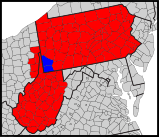
Description: Map of counties in the Washington Presbytery (blue), shown within the Synod of the Trinity (red).
Title: Washington Presbytery map
Credit: Synod_of_the_Trinity_map_-_border.svg
Author: Synod_of_the_Trinity_map_-_border.svg: *Usa_counties_large.svg: *USA_Counties.svg: U.S. Census Bureau derivative work: Abe.suleiman (talk) derivative work: GrapedApe (talk) derivative work: GrapedApe (talk)
Usage Terms: Public domain
License: Public domain
Attribution Required?: No
Image usage
The following page links to this image:

All content from Kiddle encyclopedia articles (including the article images and facts) can be freely used under Attribution-ShareAlike license, unless stated otherwise.