
Image: Westminster Civil Parish Map 1870

Size of this preview: 800 × 528 pixels. Other resolutions: 320 × 211 pixels | 8,153 × 5,384 pixels.
Original image (8,153 × 5,384 pixels, file size: 2.07 MB, MIME type: image/png)
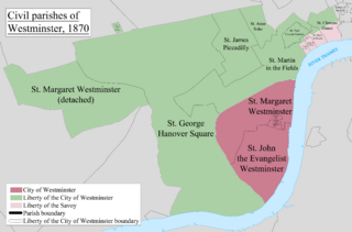
Description: A map showing the civil parishes of Westminster as they appeared in 1870. Based on the Ordnance Survey Town Plan of London (1871-76) at 1:1056 scale.
Title: Westminster Civil Parish Map 1870
Credit: Own work
Author: Doc77can
Usage Terms: Creative Commons Attribution-Share Alike 3.0
License: CC BY-SA 3.0
License Link: http://creativecommons.org/licenses/by-sa/3.0
Attribution Required?: Yes
Image usage
The following 15 pages link to this image:
- City and Liberty of Westminster
- Civil parish
- Civil parishes in England
- Close of the Collegiate Church of St Peter
- Liberty of the Rolls
- Liberty of the Savoy
- St Anne Within the Liberty of Westminster
- St Clement Danes (parish)
- St George Hanover Square
- St Martin-in-the-Fields (parish)
- St Mary le Strand (parish)
- St Paul Covent Garden
- Westminster
- Westminster St James
- Westminster St Margaret and St John

All content from Kiddle encyclopedia articles (including the article images and facts) can be freely used under Attribution-ShareAlike license, unless stated otherwise.