
Image: Whewell tidal chart Britain and Ireland 1836 amphidromic point southern North Sea

Size of this preview: 691 × 599 pixels. Other resolutions: 277 × 240 pixels | 1,490 × 1,292 pixels.
Original image (1,490 × 1,292 pixels, file size: 487 KB, MIME type: image/jpeg)
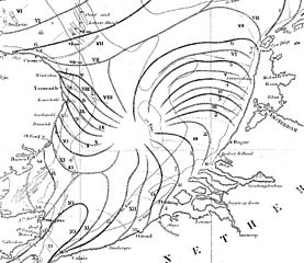
Description: Chart of the coasts of Britain Ireland and the North Sea showing cotidal lines. Plate 24 p307 from Whewell, William (1836). "On the results of an extensive system of tide observations made on the coasts of Europe and America in June 1835". Philosophical Transactions 126: 289-341.
Title: Whewell tidal chart Britain and Ireland 1836 amphidromic point southern North Sea
Credit: https://archive.org/details/jstor-108036
Author: William Whewell
Usage Terms: Public domain
License: Public domain
Attribution Required?: No
Image usage
The following page links to this image:

All content from Kiddle encyclopedia articles (including the article images and facts) can be freely used under Attribution-ShareAlike license, unless stated otherwise.