
Image: William Smith geological map of Cumberland

Size of this preview: 521 × 600 pixels. Other resolutions: 208 × 240 pixels | 1,070 × 1,232 pixels.
Original image (1,070 × 1,232 pixels, file size: 506 KB, MIME type: image/jpeg)
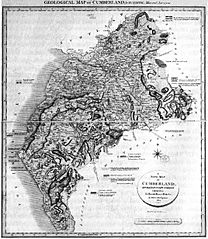
Description: William Smith's geological map of Cumberland, 1824
Title: William Smith geological map of Cumberland
Credit: Scan by User:Geoz, 2005. Some image editing by Jo
Author: drwan by en:William Smith, scan by User:Geoz, 2005. Some image editing by Jo, 2008
Usage Terms: Public domain
License: Public domain
Attribution Required?: No
Image usage
The following page links to this image:

All content from Kiddle encyclopedia articles (including the article images and facts) can be freely used under Attribution-ShareAlike license, unless stated otherwise.