
Image: Wpdms nasa topo wind-bighorn river
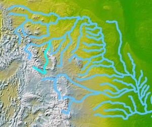
Description: Map of the Wind-Bighorn Rivers System or Wind River—Bighorn River System. Located in the Bighorn River Basin (watershed) of central-northern Wyoming and southern Montana. The upper reaches of the system in the Wind River Range are known as the Wind River. The Wind River officially becomes the Bighorn River at the 'Wedding of the Waters' confluence at the northern end of Wind River Canyon (near Thermopolis, Wyoming). The two rivers are sometimes referred to as the singular Wind/Bighorn River — and are tributaries of the Yellowstone River, which is a major tributary of the upper Missouri River. © 2004 Matthew Trump
Title: Wpdms nasa topo wind-bighorn river
Credit: Transferred from en.wikipedia to Commons.
Author: The original uploader was Decumanus at English Wikipedia.
Usage Terms: Creative Commons Attribution-Share Alike 3.0 truetrue
License: CC-BY-SA-3.0
License Link: http://creativecommons.org/licenses/by-sa/3.0/
Attribution Required?: Yes
Image usage
The following page links to this image:
