
Image: WrexhamBuiltUpArea

Size of this preview: 728 × 600 pixels. Other resolutions: 292 × 240 pixels | 850 × 700 pixels.
Original image (850 × 700 pixels, file size: 202 KB, MIME type: image/png)
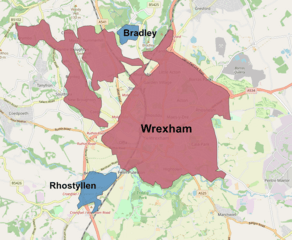
Description: Map of the Wrexham Built-up area (BUA) or Wrexham Urban area, roughly following the boundaries used by the Office for National Statistics. Red indicates the main Wrexham urban agglomerate and blue for urban areas physically separate but considered a sub-division of the Wrexham BUA.
Title: WrexhamBuiltUpArea
Credit: Own work, using rough boundaries used by the Office for National Statistics at statistics.data.gov.uk, and Openstreetmap data.
Author: Dank · Jay
Usage Terms: Creative Commons Attribution-Share Alike 4.0
License: CC BY-SA 4.0
License Link: https://creativecommons.org/licenses/by-sa/4.0
Attribution Required?: Yes
Image usage
The following page links to this image:

All content from Kiddle encyclopedia articles (including the article images and facts) can be freely used under Attribution-ShareAlike license, unless stated otherwise.